Posted by: carogouin | November 21, 2009

the ring of fire

Volcano number 4 - Concepcion.

As we continue our journey through Central America, we seem often to find ourselves face to face with cone-shaped peaks spewing smoke, lava (if we’re lucky), and standing imposingly tall above the tropical jungle. Call it a fascination with the earth’s age-old mechanism of simultaneously destroying and rejuvenating itself, or perhaps the fact that we are smack dab in the middle of the Pacific Ring Fire Circle (Costa Rica alone has 200 volcanic formations, with half of these showing signs of activity, and 5 “technically” active) and cannot avoid them even if we tried.  In any case, we’ve been hooked on this ring of fire ever since we set foot in Costa Rica.  The first one we visited and the most active in Costa Rica, Volcán Arenal near la Fortuna, started it all.  And although we didn’t exactly see the emblematic red lava at night, it only wet our appetite for more.

So we continue on the ring of fire, but first make a pit stop at Monteverde National Park to see another wonder of CR – the cloud forest, home to over 100 species of mammals and 400 species of birds. Because of its high altitude in the clouds, they say a light mist always falls on this wildlife refuge – to our misfortune, a great understatement. We were trapped in a terrible downpour for about 2 hours, which prevented any bird or animal sightings, or much visibility at the miradores (overlooks). We sought refuge in a makeshift shelter for about 45 minutes, but then realized it was a lost cause and braved the monsoon to finish our loop and exit the park.

A clouded vista after a long uphill trek - ugh.

The trail through the veritable cloud forest at Monteverde.

Seeking refuge under a shelter during a Monteverde downpour.

We quickly headed to Liberia for lower and dryer ground (I use “quickly” loosely, since we took a series of three local buses colectivos, which pick up passengers every 500 meters or so) to explore our second active volcano – Rincón de la Vieja. We decided to rent a car after realizing that a taxi ride from Liberia to the volcano is $20 per person each way – believe it or not, our 4WD Montero for 2 days was much more economical.  And of course, because we’ve been missing the Jeep terribly. It proved to be a great move, since upon arrival at the park on Monday morning, we learned that side of the park is always closed on Mondays (a fact that even the locals did not know). So we turned this into an opportunity to make use of the vehicle, and drove as far west as we could until we reached the Pacific cost at Playa El Coco. We spent the entire afternoon swimming in the 80 degree water, watching locals carry the fresh catch of the day over their shoulders, and ended the evening with the most fabulous whole fish we have ever tasted (it was drenched in some kind of garlic, onion and butter sauce).

A local fisherman with a dorado over his shoulder at Playa El Coco.

Colorful skies while eating the best fish ever at Playa El Coco.

The next morning we get an alpine start, feast on a hearty breakfast of cornflakes and warm milk, and head over to the park again. When we checked in with the guard and told him we were planning on going all the way up to the crater, he dissuaded us with talks of clouds, rain and no puede ver (can’t see). Having been robbed of well-earned vistas a little too often recently, we listened.  Our decision can also be attributed to the seismic activity discovered the week prior, and the missing poster we spotted of a gringo who attempted the climb recently. Probably for the best. However, we didn’t miss out on the adventure completely.  We instead followed a 2-hour loop around a series of fumaroles (holes in the earth that release sulphuric smoke), boiling mud pits and volcancitos (tiny volcanoes): definite clues that you are walking above geothermal activity.

A fumarole steaming in the early morning at Rincon de la Vieja.

Boiling mud pits - stay away!

Cascading waterfall at the base of Rincon de la Vieja.

Since we were so close to the border with Nicaragua, we decided to cross over and check it out.  We had been hearing lots of accolades from other travelers who were praising unspoiled territory, cheap prices, less gringos, beautiful colonial towns, etc. So we went, and after an hour and half at the border (which went relatively smoothly since a gracious Canadian acted as our guide), a chicken bus (there was a rooster), touts and vendors selling about most anything (our favorite – water in plastic bags where you rip off a corner and suck it down – very sanitary), and a short moto rickshaw ride (the bus dropped us off at an intersection of the highway, so we had no choice), we finally arrived in Granada – a beautiful colonial town indeed with impressive churches, Spanish architecture and courtyards hiding gorgeous gardens. A sort of silver lining over what is, without a doubt, still a developing country.  We spent three days exploring the city, sitting by these lovely hidden courtyards, and of course visiting nearby volcanoes.

On the moto rickshaw for the final stretch to Granada, Nicaragua.

The cobble stoned steets of beautiful Granada.

The Cathedral towering over Granada plaza central.

One of the many lovely courtyards in Granada.

We booked a tour with a Nicaraguan guide who had spent 20 years in Dallas and spoke English fairly well, along with three American girls, all fun-loving traveling nurses.  Our first stop was a pottery town known for its clay-rich soil where we watched local artists demonstrate ceramic making.  The number of steps and precision involved was astonishing.  It takes about 15 days to finalize a piece – but of course they produce about 200 pieces in this 15-day cycle. Next, we stopped at the Lago de Apoyo, a deep crater lake perfect for swimming and lounging by the shore with a cerveza.  Finally we made it to the Masaya National Park – home of the Nigiri volcano with one active crater – Santiago. It was breathtaking to stare down into an active crater – not to mention the sulphuric smoke that literally took your breath away.  We learned that during the civil war Sandinistas and Contras alike would drop their enemies alive into this burning chamber. What?!!?  What a creative and sadistic torture mechanism.  

A local artist demonstrating ceramic work - spinning the wheel with his foot.

Just some horses bathing in the lagoon, Lago de Apoyo.

The Santiago crater of the Nigiri volcano of the Masaya National Park

Pat standing next to the hot magma chamber - where Sandinistas and Contras dropped in their enemies - no joke!

The whole crew at the top of the hike to the crater rim.

Sulphuric smoke surrounding the craters of Masaya.

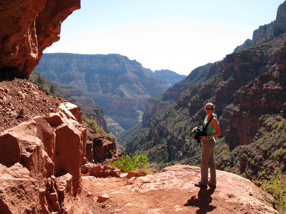
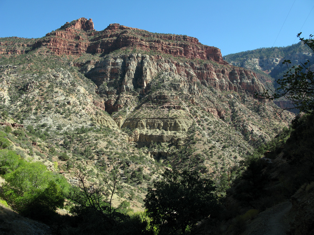
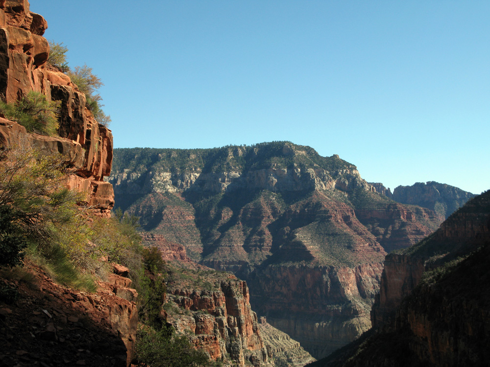
Next stop after Granada?  You guessed it – another volcano.  However this one – Volcán Concepción – together with its smaller neighbor Volcán Maderas connected by an isthmus, form the island of Ometepe in the middle of Lake Nicaragua.  We took an hour long ferry from San Jorge and reached this remote paradise with a surprisingly bustling and friendly community. For this volcano we were determined to make it to the top.  The last major eruption was in 1957, but we learned afterwards of a small pyroclastic eruption in August 2008, hmmm. Shielded from this information, we hired a guide to take us up the mountain.  Meet Yojan: a 26-year old local with incredible physique and stamina who has climbed this volcano over 500 times – and did so that day with a bit of a hangover.  The only thing that suffered was his English.

Without any idea of what we were getting ourselves into, we started our trek through the jungle with Yojan, a Swiss couple on a similar 6-month journey through Central and South America, and two 19-year old students from Norway and Holland with high-top converse shoes.  The first 3.5 km climb in the forest was pretty standard, passing banana trees, white-faced capuchin monkeys, and hearing howler monkeys in the distance. We climbed out of the tree line and arrived at the saddle, almost knocked over by the wind.  But my oh my did we have an awesome view of the island, lake and even the Pacific Ocean off in the distance. As we refueled, Yojan informed us that the next 1km would be very rocky and take about 2.5 hours. 

On the ferry to Isla de Ometepe - home to Volcan Concepcion y Maderas.

Steep scree, loose volcanic rock for the last 1 km to the top of Concepcion.

The final 1 km to the summit, in fact, took us 2 hours as we slowly pulled ourselves (often using our hands) up a 47 degree slope covered with loose volcanic rock. There were no trails, no switchbacks, just a steady climb straight up. At a moment of rest while I feared for my life just a little, I made the mistake of asking Yojan if it got any worse.  He informed me that it did, and that the first time he climbed the volcano when he was 14, he found a dead body.  Thanks Yojan.

We finally made it to the top, with a cliff on one side and the crater on the other.  We did not see a dead body, but we didn’t really see much else either since it was too cloudy.  We nervously congratulated ourselves for making it, but we knew it was far from over.  The downhill would be more treacherous. Every step had to be carefully calculated and tested, otherwise you’d knock off small or sometimes large rocks and threaten your fellow hikers below you.  I’ve never descended a mountain so slowly or rejoiced so much when we finally made it down.  We all made it down safely in the end, each with a minor slip and scrape, but with a true sense of accomplishment and relief.

At the top of volcano Concepcion! Crater on one side, cliff on the other!

Looking down on the isla on the slopes of the volcano at a 47 degree angle!

Pat and I spent the next 2 days doing absolutely nothing.  We retreated to a comfortable bungalow with a lake-side view, settled ourselves in hammocks reading books, listening to the tide, and nursing our sore muscles back to health. When we were strong enough to move on, we took a ferry back to the mainland and made our final stop in Nicaragua at San Juan del Sur – a lovely and popular beach on the Pacific with lots of good restaurants and surf shops. We quickly jumped on the bandwagon and tried our hand at surfing on another beach just north of San Juan del Sur called Madera. We spent all day playing in the water, catching waves (Pat did most of the surfing, I just body boarded a few times), eating fish tacos and talking to other gringos doing the same.  It was an extraordinary day and a perfect culmination to our sojourn in Nicaragua.

Treating ourselves to a comfortable bungalow on the Isla de Ometepe.

Our perfect relaxation spot for the next 2 days.

Madera - a beautiful, serene beach north of San Juan del Sur.

Which is a popular spot for surfers.

Pat rides one in.

Beaming after a day of catching waves.

Posted by: Patrick | November 7, 2009

it’s good to be back

IMG_5695

Welcome to Costa Rica.

Back to the world of rice and beans with every meal, constant horn blasts from buses, taxis, motos – everything that moves, more pedestrians than cars, holes in the sidewalk that could swallow a donkey, barbed wire tops every wall, low prices, waking up to roosters, being overcharged in taxis, extremely friendly happy people, orange fanta with real sugar, coke in the old school glass bottles, kids smiling at you at every turn.  Not understanding much of the language but getting by just fine.  Oh and the smells!  The scent of the tropics: thick humid air with a few parts burning plastic, sugar cane, unmuffeled diesel, hot garbage, sweet pineapple, plantain and banana all baked under a burning sun.  It’s delightful.  I didn’t know how much I missed it, but I’m falling in love all over again.  Ahh the developing world — the real world.  Where more than four of the six billion people on this planet live.  Not much is perfect, spotless, organized or particularly safe.  It’s all different, metric, Tico, laid back, bus will leave when it’s full, beer is delicious and cheap, no schedule, pura vida!

We arrived on Halloween in San Jose, the capital of Costa Rica.  It was Saturday,we checked into our guesthouse and it was nice and cheap.  No problems getting through customs with our one-way flight.  How long will you stay? Four weeks.  Bueno.  Walked around town, safe enough, good restaurants down the street, friendly helpful folks point us in the right direction.   The ATM accepts our card, gives us cash, shows our balance in colones – instant millionaires.  The dollar is still strong in some places, this is one of them.   The next day we explored San Jose, mostly quiet on Sunday, perfect for walking the streets and getting comfortable, adjusted.  Our first real destination was Volcano Arenal, near the town of La Fortuna and El Castillo in the central highlands.  Up early on Monday, four and a half hours on a hot bus that got packed eventually but wasn’t too bad.  On the ride we met Ansgar and Becky, a German couple on holiday for a few weeks.  We were staying at nearby hotels in El Castillo, so we met up for a couple dinners, hikes and hot springs.  Good times with good people. We really enjoyed their company for a few days, it was sad to see them go.  On to the cloud forests and mountains of Monteverde.  This is my first time in Costa Rica, though at times it could be St. Thomas, Nairobi or Kathmandu… it’s good to be back.

IMG_5599

Walking the streets of San Jose.

IMG_5600

A healthy obsession with Jesus.

IMG_5612

Our first 'hotel' in a while. It was nice!

IMG_5628

Volcano Arenal through the trees.


An owl eye butterfly.

An owl eye butterfly.

IMG_5637

With our friends Ansgar and Becky at the base of Arenal.

IMG_5638

A white headed capuchin monkey on the hike to Arenal.

Spewing ash at night, but nothing pyroclastic.

Spewing ash at night, but nothing pyroclastic.

IMG_5661

A rare clear moment of Arenal during the day.

IMG_5664

Hiking down to La Fortuna falls.

IMG_5673

Macro caterpillar!

IMG_5674

Quite the photogenic waterfall, I took a few too many photos.

IMG_5675

It was a long hike down but worth it for sure.

IMG_5690

Pura Vida.

Posted by: carogouin | October 31, 2009

how the west was won

IMG_5494

Saguaro cacti at sunset.

When we reached John and Julia’s place in Scottsdale (Pat’s aunt and uncle), we realized that our time in the US was quickly coming to an end.  John and Julia generously offered to safeguard our Jeep in their driveway while we cross the border to poke around in Central and South America for a while. Consequently, this made Phoenix our official exit point out of the country.  But we weren’t ready to call it quits yet and yearned for just a little more time with our comfortable and reliable Jeep, our luxurious tent, our bikes, and of course the freedom to just get in the car and drive.  So after buying one way tickets to Costa Rica (yay!), we got back in the car and took one final road trip to explore southern Arizona.

This being our last week in the US, we were committed to saving as much money as possible and taking full advantage of our camping gear.  So we went grocery shopping at Trader Joes and vowed not to eat out at all for the remainder of the trip and thus cook every meal on our two-burner stove (we almost made it – we bought lunch twice).  Similarly, we were pleased to take advantage of our National Park pass one last time (we’ve been to 16 total – thanks Jim and Kathy!) and visited the Saguaro (pronounced sa-WAH-ro) National Park on the west side of Tucson.  Picture the classic desert, multi-armed cactus – we were swimming in a forest of them!  We had fun attributing personalities to each and estimating their age (some live to be 200 years old).  We followed the Wasso Peak trail, which provided 360 views of Tucson and its suburbs against a setting sun.  We almost ran out of light coming down. That night we stayed at a nearby campground and cooked our second lamb steak dinner of the trip!

IMG_5444

Hiking in Saguaro National Park West

IMG_5446

Caro's not afraid of no cactus!

IMG_5448

They get big!

IMG_5472

The trail up Wasso peak overlooks Tucson.

IMG_5478

View from the top just before sunset.

The next day we went to the Pima Air and Space Museum and examined the evolution of civilian and military aircrafts, including the famously stealth Blackbird and a slew of other fighter, cargo and bomber planes now out of commission.  We stayed a couple more nights in Tucson, however this time in a friendly, multicultural hostel in downtown Tucson.  Not to worry, we were still able to sleep in out roof-top tent, as they let us occupy 2 spots in their small parking lot in the back. For only $20 a night, we had access to all their facilities: showers, kitchen, communal area, wifi, etc., and met some really interesting people.  The only downside was that we were right next to train tracks and not too far from the Airforce base – thank goodness for ear plugs.

IMG_5498

Blackbird at the Pima Air & Space museum.

IMG_5505

Caro having some fun with the mega lift heli.

IMG_5517

Taking 2 parking spots at the Roadrunner Hostel.

Knowing it was close, we went looking for the Airforce base on our bikes the following day. Despite 20 miles of riding, we didn’t quite make it to the runway, but we did pass a giant solar panel farm in construction and the Airforce “boneyard”.  We stayed one last night in Tucson and decided to continue south all the way down to Bisbee, a cute mining town with a many art galleries and a very European feel.  We bought a bottle of port wine and cooked a delicious pasta dinner with pesto chicken sausage and portabella mushrooms.

IMG_5520

The boneyard.

Having gone as far south as we could before hitting Mexico, we drove back north again to finish up our loop.  Along the way, we stopped at the famous town of Tombstone. Very entertaining indeed – they had a variety of cowboy reenactments on the street. A bit too touristy for us, we decided to move on and get in a last bit of off-roading with the Jeep.  We drove on dirt roads over the Dragoon mountains and settled at the Cochise Stronghold campground – ancient home of the Apache Indians (who raided the settlers in the valley and retreated to these mountains).  Ready to eat our measly salad for dinner, we were approached by two women camping nearby who had mistakenly bought too many t-bone steaks and asked if we could please help eat them.  We of course readily accepted and joined them for a warm and convivial dinner. Although we had the better sleeping arrangements, they definitely topped us with their camping gear, including a good sized propane oven for baking biscuits!

IMG_5548a

Caro checks out Cochise.

IMG_5552

Cochise's stronghold in the Dragoon Mountains.

The following day we continued northward back towards Phoenix and settled at our last campsite in the US!  We found a great spot on Roosevelt Lake and enjoyed our last nights with the Jeep.  Pat went for one last mountain bike ride around the lake before packing up the bikes for good. We set up hammocks and relaxed as we watched an unusual haze creep over us, an anomaly for Arizona.  Although we didn’t get a rain storm, we certainly got a wind storm, and spent our last night listening to our tent flapping in the wind.  We soon accepted it as music to our ears, as we embraced the warmth and comfort of our humble roof-top home.

IMG_5558

Our last campsite with the Jeep. We'll miss you!

IMG_5560

We've had an excellent time camping in 'our rig.'

A bit tired but quietly satisfied, we followed our final scenic route back to Phoenix, past familiar saguaros, lichen-scarred rock faces, and countless mesa tops – all treasures of the great Southwest. At the close of 3 months, we feel grateful to have visited such stunning places, learned about the interesting flora and fauna of this spectacular part of the world, all while sharing it with a few friends along the way.

We’d like thank John and Julia for taking us into their home, twice, and enabling our journey forward sans Jeep. We hope all of you have enjoyed our diaries to date, and we hope you continue to follow along as we enter the next phase of our trip.  We certainly look forward to sharing our stories as we explore the rest of the Americas! 

Thanks again and we’ll be in touch in Costa Rica!

IMG_5583

bing! Our National Park map collection, which we're very proud of.

IMG_5580

Uncle John and Aunt Julia - our fabulous hosts.

IMG_5588

The Jeep's new home in Arizona at John and Julia's.

Posted by: Patrick | October 30, 2009

the Grand tour

We made it! The Grand Canyon.

We had a fantastic time with Jesse and Steve on our whirlwind northern Arizona tour, but eventually had to leave the comfy confines of Steve’s place in Prescott and head back out on our own. Our first stop was one of the big goals of the trip, the Grand Canyon. We spent a night on the south rim first, then drove the 208 miles to the checkout the more secluded north rim too. Both sides were spectacular!  We’ve seen a lot of canyons thus far, but we certainly saved the best for last. On the north rim we hiked down about 5 miles into the canyon to a waterfall and then back out again. It was a tough hike, because of the steep elevation loss and gain. We’ve been getting pretty fit with all these hikes and bike rides, so we were proud to make the hike out in just over two hours.

Caro on the south rim of the Grand Canyon.

Sunset on the south rim.

We got there just in time for a beautiful sunset.

Looking down towards Plateau Point.

The north rim is considerably colder.

Looking out on Bright Angel Canyon.

Narrow trail, great views.

A weathered old pine.

Hiking down it got a lot warmer.

A tough hike down about 5 miles.

Layers of time.

Both nights on the Grand Canyon rim were well below freezing, I mean frigid about 18F!  We were in two sleeping bags each, both had Nalgene’s full of boiling water to keep us warm and were layered up with fleece.  We survived but they weren’t our best nights sleep. So we were looking forward to lower elevations and higher temperatures in Utah.  We continued north to check out the parks we had missed in our hurry to meet the guys in Prescott.  It was a quick drive from the north rim towards Hurricane Utah, a town near Zion National Park.  Arriving on a Saturday in Hurricane, we decided to lay low to let the crowds die down over the weekend in the park.  Hurricane was lots of fun with great mountain biking all around.  Our first night we found a comfy state park to camp in, just on the edge of town.  The next night we camped for free next to Zion on a ridge with views of the peaks all around us.

Moth massacre on the road to Utah.

Superb campsite just outside Hurricane Utah.

A fine view to wake up to.

Sunset over Zion NP, at another great free campsite.

After two days camping near Zion, we finally made it into the park for the famous Angels Landing hike.  It’s a steep switchbacking trail up to a high point in the middle of the park.  Near the top, the trail gets very narrow with a lot of exposure on either side.  We enjoyed the view up a the top and then headed down for a hearty lunch at the lodge.  Zion was worth the wait, it’s a strikingly beautiful canyon with the clear Virgin river cutting through the middle.  The park facilities are top notch; we enjoyed relaxing after the hike in an updated lodge and the informative visitor center.

Looking down the canyon in Zion.

Paved switchbacks up to Angels Landing.

Watch your step.

The view from our campsite on the rim at Gooseberry Mesa.

On our last night in the Zion area we camped for free at Goosebery Mesa, a large plateau overlooking the Hurricane Valley.  We tried to save as much cash as we could before heading to our next stop: Las Vegas!!  We found a great deal online and booked two nights at the MGM Grand.  We lived large for a few days eating better than ever and even went out to a spectacular show:  Cirque du Soleil – KA.  It was a welcome break from all this ‘roughing it.’

From this...

...to this!

Vegas baby.

Mmmm, we stuffed ourselves at the Wynn Buffet.

Three days in Vegas was enough; we were rested, relaxed and completely stuffed from all the wonderful buffets.  We headed back towards Arizona where we had plans to spend a few days with my Aunt and Uncle in Scottsdale, AZ.  Before getting down to Scottsdale we swung back through Prescott and visited Steve again.  On our way down, He called us up to ask if we could get there a little earlier since he had rented a plane (a tricked out Cessna 172) for the evening.  We were stoked!  It was a cool clear night, perfect for the short flight over to Sedona where the airport restaurant was having all-you-can-eat king crab night.  Steve kept mentioning, sort of jokingly, how Caroline was going to takeoff and I was going to land…  We both thought he was kidding, but he was not!  It was an awesome flight and night.

Little did Caro know SHE would be flying us to Sedona.

At this point she still doesn’t know.

What do you mean pitch up?

Turns out Caro is a great pilot! Looking back at Prescott airport just after takeoff.

Sunset over Prescott AZ.

Pat landed us smoothly back in Prescott after dinner. See the white knuckles?

 On our way down to Scottsdale, we made a stop in Camp Verde where the main attraction is the Out of Africa wildlife park.  We got there just in time for the afternoon feed.  It was awesome; the lions were pacing and foaming at the mouth waiting for the meat to get tossed over the fence.

Tiger!

Simba relaxing in the shade.

Feeding time.

My Uncle John and Aunt Julia have a lovely comfortable home in Scottsdale where we recharged for a few days before the final leg of our southwest tour through southern Arizona.  They’re travelers to; we really enjoyed catching up with them and hearing about all of their adventures near and far.  Also, they put together an excellent slideshow of their recent trip to Turkey, I’d love to add that to the itinerary!  We’ll see… 

Saguaro on the morning walk around the neighborhood in Scottsdale.

« Newer Posts - Older Posts »

Categories